

Women who put GEOINT on the map
By NGA’s Office of Corporate Communications
March 14, 2016
Story updated March 2019
We look back on the legacies of some of the amazing women who have contributed to the field of geospatial intelligence. Pioneers in their fields, these women broke down barriers, defied expectations and continue to inspire us daily at the National Geospatial-Intelligence Agency.

Sacagawea
Sacagawea, a teenage Lemhi Shoshone woman, accompanied Captains Meriwether Lewis and William Clark during their exploration of the Western United States between 1804 and 1806. Acting as an interpreter and guide, Sacagawea contributed significantly to the success of the journey.
In November 1804, Sacagawea’s husband, Toussaint Charbonneau, was hired by Lewis and Clark to assist them and the Corps of Discovery as they explored the Louisiana Purchase. Sacagawea, six months pregnant at the start of her journey, was a vital part of the exploration, as she spoke several native languages and was knowledgeable about plants and wildlife previously unknown to the Corps of Discovery.
Once Lewis and Clark reached the upper Missouri River, Sacagawea’s knowledge of the landscape and the Shoshone language proved invaluable and was an early example of the value of geospatial intelligence and human geography.
Human geography is a century-old social science discipline that looks for interconnections between people and places, including how people use the physical landscape and how, based on a number of factors, that use evolves over time. Using this discipline, NGA and others in the intelligence community analyze ethnicity, language, religion, demographics, economics, education, water and land use, transportation and natural resource.
The story of Sacagawea is reflected in NGA’s motto, “Know the Earth… Show the Way… Understand the World.”

Mary Sears
During World War II, Massachusetts native and STEM pioneer Mary Sears left her job as a research assistant at the Woods Hole Oceanographic Institution to answer her country’s call to duty. As a Navy lieutenant in the Women Accepted for Volunteer Emergency Service, or WAVES, she was appointed head the Navy Hydrographic Office’s new Oceanographic Unit, which was created in 1943. This marked the beginning of military efforts to consolidate oceanographic programs.
Sears’ research while in the WAVES proved critical to the survivability of U.S. submarines during the war. Her intelligence reports, “Submarine Supplements to the Sailing Directions,” predicted the presence of thermoclines — areas of rapid water temperature change — under which a submarine could hide to escape enemy detection by surface sonar. Following the war, the Navy Hydrographic Office formally established a Division of Oceanography and Sears was appointed its first officer-in-charge. In 1963, Sears retired from the U.S. Naval Reserve as a commander. Woods Hole designated her a senior scientist in its biology department, from which she retired in 1970.
NGA continues legendary oceanographer Mary Sears’ pioneering endeavors. The agency’s bathymetrists evaluate and extract hydrographic and bathymetric data to support safety in maritime navigation. To meet customer requirements, bathymetrists also create geospatial displays and textual reports of intelligence information. NGA Bathymetric Contour Charts play a vital role in underwater navigation and enable Navy submarines to support the nation’s interests around the world. These and other maritime safety efforts build on the foundation Mary Sears helped establish.
Learn more: About Mary Sears | Woods Hole Oceanographic Institution

Military Mapping Maidens
Just as the demand for mapping products was escalating early in World War II, the Army Map Service — a NGA predecessor organization— was losing much of its workforce to the armed forces.
A solution to the urgent need for replacements emerged when the University of Chicago’s Geography Department developed a course in military map making and began offering it to women’s colleges in the east and midwest.
In its inaugural year, 200 women completed the course. As the program expanded to more colleges, AMS provided a four-week course that gave recruits further training. The “Military Mapping Maidens” — or “3Ms” — charted strategic locations, churches, schools, land contours, bodies of water and roads. They used foreign maps, aerial photos and other information to create the maps. Some were printed on silk and carried by troops as survival tools.
Learn more: NGA.mil | Military Mapping Maidens chart course for today’s mapmakers
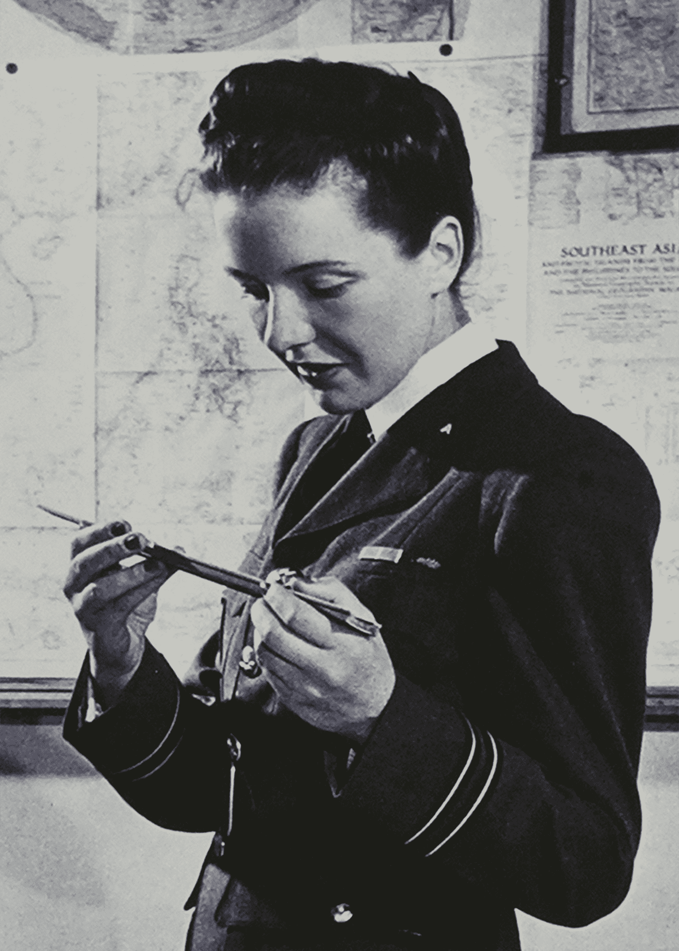
Constance Babington Smith
Constance Babington Smith was a pioneer in the field of aircraft based photographic interpretation and is the first Commonwealth partner to be inducted into NGA’s Geospatial Intelligence Hall of Fame. Following the outbreak of World War II, she joined the Women’s Auxiliary Air Force in support of the Royal Air Force as a photographic interpreter. She was later assigned to the Central Interpretation Unit at RAF Medmenham, where she commanded the Aircraft and Aircraft Industry section. Following victory in Europe, Constance Babington Smith transferred to the United States and contributed to the allied effort in the war against Japan. Her expertise and methodology significantly influenced American interpretative processes.
King George VI bestowed the Order of the British Empire upon Babington Smith in 1945, she also received the 1939–1945 British Star, the Defense Medal, the War Medal, and was the first British woman to receive the United States’ Legion of Merit. Babington Smith wrote several books, including “Air Spy: The Story of Photo Intelligence in World War II and Evidence in Camera.”

Irene K. Fischer
During her 25-year career with the Army Map Service, Austrian-born geodesist Irene K. Fischer became a pioneer for women in science, technology, electronics and mathematics as a pioneer in geodesy — the science of accurately measuring and understanding earth’s geometric shape, its orientation in space, and its gravity field.
After studying mathematics at the University of Vienna, Fischer married and founded a kindergarten in Vienna. Her quiet life was shattered when Adolf Hitler annexed Austria in 1938. Fleeing Austria with her family, Fischer ended up in Potomac, Maryland, working for AMS and was instrumental in developing what became the World Geodetic System. She was the first AMS employee to receive the Distinguished Civilian Service Award, the highest honor given by the Secretary of Defense to career civilian personnel.
Learn more: Irene K. Fischer measured Earth

Marie Tharp
After initially studying English and music during her undergraduate years at Ohio University, Marie Tharp turned to the sciences, earning her master’s degrees in geology and mathematics, and became a STEM pioneer for women everywhere.
Best known as the oceanographic cartographer that produced the comprehensive map of the world’s ocean floor with Dr. Bruce Heezen, Tharp made the once-mysterious “blank canvas” of the ocean depths real and tangible.
“[It was] a fascinating jigsaw puzzle to piece together,” she said in 1999. “It was a once-in-a-lifetime — an once-in-the-history-of-the-world — opportunity for anyone, but especially a woman in the 1940s.”
For more: How One Woman’s Discovery Shook the Foundations of Geology

Dr. Gladys West
Born in 1930 in rural Virginia, Gladys West pursued higher education to escape the farm life. She graduated high school at the top of her class and was offered a scholarship to the local university. In college, she studied math, a subject mostly studied by men. A few years after graduation she received a job at the Naval Surface Warfare Center in Dahlgreen, Virginia, where she would collect and analyze data from satellites, to help determine their exact location. This information would go on the help develop the global positioning system, or more commonly known as, GPS. In 2018, Dr. West was inducted into the prestigious Air Force Hall of fame.

Dr. Annette J. Krygiel
Dr. Annette J. Krygiel spent her career in the Department of Defense as a leader in a male-dominated field. During her 38-year federal career, she managed geodetic and gravimetric programs and oversaw the development of computer science and telecommunications applications for mapping.
With a Ph.D. in computer science, Krygiel served in a variety of STEM leadership positions at NGA heritage organizations. After starting her career at the Aeronautical Chart and Information Center in 1963, she served as chief scientist at the Defense Mapping Agency and was the final director of the Central Imagery Office. When the National Imagery and Mapping Agency was formed in 1996, Krygiel became deputy director for Systems and Technology — the highest-ranking woman at the young agency. NGA inducted her into the GEOINT Hall of Fame in 2001.

Roberta “Bobbi” Lenczowski
Bobbi Lenczowski retired in 2005 from NGA, where she finished her NGA career as executive director of NGA Campus West in St. Louis. During her tenure in Washington, D.C., Lenczowski served three years as NGA’s technical executive, and was also director of operations with the National Imagery and Mapping Agency for more than five years. She also served as president of the American Society for Photogrammetry and Remote Sensing and represented NGA on the National Oceanic and Atmospheric Administration’s Advisory Committee on Commercial Remote Sensing and the Department of the Interior’s National Satellite Land Remote Sensing Data Archive Advisory Committee, and the Security Affairs Support Association.

Letitia A. Long
On Aug. 9, 2010, Letitia A. Long became the fifth director of NGA and the first woman to head a major U.S. intelligence agency. During her tenure as director, Long introduced a number of changes to the agency to put “the power of GEOINT” into the hands of the user while continuing to provide timely, relevant and accurate GEOINT in support of warfighters, policymakers and first responders.
Long guided NGA through the culmination of two wars, a government shutdown and new and evolving threats to national security. Under Long’s leadership, NGA provided critical support to the raid that killed Usama Bin Laden, provided relief in the aftermath of Hurricane Sandy and monitored the Fukushima Daiichi nuclear plant in the aftermath of the Japanese earthquake and tsunami, all while providing notification and warning on developing crises throughout Asia, Africa and the Middle East.
Long will “always have a place in history as one of the Nation’s most important figures in military and national intelligence,” said Senator Dianne Feinstein, Chairman of the Senate Select Committee on Intelligence, in a tribute to Long in the US Senate Congressional Record upon her retirement on Oct. 3, 2014 after 36 years of federal service.