About the National Geospatial-Intelligence Agency
The National Geospatial-Intelligence Agency (NGA) delivers world-class geospatial intelligence that provides a decisive advantage to policymakers, military service members, intelligence professionals and first responders.
NGA is a unique combination of a Department of Defense (DOD) combat support agency and a principal member of the U.S. intelligence community. NGA gives warfighters, the IC and first responders a worldwide, firsthand intelligence baseline for their own analytical and operational needs. This includes everything from contributing to the state of readiness of our military forces to ensuring safety of navigation in the air, on land and over/under the seas. NGA also helps protect the homeland by providing critical insight for humanitarian efforts, disaster relief and recovery operations. Anyone who sails a U.S. ship, flies a U.S. aircraft, makes national policy decisions, fights wars, locates targets, responds to natural disasters or navigates with a cellphone relies on NGA. This agency enables all of the critical actions and shapes decisions that impact our world through the indispensable discipline of geospatial intelligence, also known as GEOINT.
GEOINT is the use of imagery, imagery intelligence and geospatial information to describe and depict features, activities and locations on Earth, helping users visualize what is happening at a particular time and place. Geospatial intelligence allows military commanders to know the exact location of U.S. Forces, coalition partners, adversaries and noncombatant persons. It predicts adversary movement based on natural and man-made obstacles. GEOINT goes beyond describing "what, where and when" to exposing "how and why."
The director of NGA serves as the IC's functional manager for GEOINT, the DOD GEOINT manager, the head of the National System for Geospatial Intelligence (NSG), and the chair of the Allied System for Geospatial Intelligence (ASG). As such, the director synchronizes operations to realize a professional, interoperable, agile and integrated GEOINT enterprise. As the lead federal agency for GEOINT, NGA manages a global consortium of more than 400 commercial and government relationships.

Leadership
-
Lieutenant General Michele Bredenkamp, Director
U.S. Army Lieutenant General Michele Bredenkamp is the ninth Director of the National Geospatial-Intelligence Agency. She leads and directs NGA under the authorities of the Secretary of War and Director of National Intelligence. She became NGA’s director on November 5, 2025.
-
Brett Markham, Deputy Director
Mr. Brett Markham serves as NGA's Deputy Director. He serves as the tenth Deputy Director of the National Geospatial-Intelligence Agency. In this role, he assists the director both in leading the agency and in managing the National System for Geospatial Intelligence. He became NGA’s Deputy Director on December 5, 2024.
-
Command Master Chief Jason Reynolds, Senior Enlisted Leader
Master Chief Jason Reynolds currently serves as NGA’s Senior Enlisted Leader. In this capacity, CMDCM Reynolds advises the NGA Director on the effective utilization of all military services members; carries the Director’s vision, mission, and intent to the workforce; focuses on NGA’s People Strategy; builds partnerships across the Joint, Interagency, Multi-national environment; and is the liaison to Senior Enlisted Leaders assigned to the National Capitol Region, other Combat Support Agencies, and the Combatant Commands.
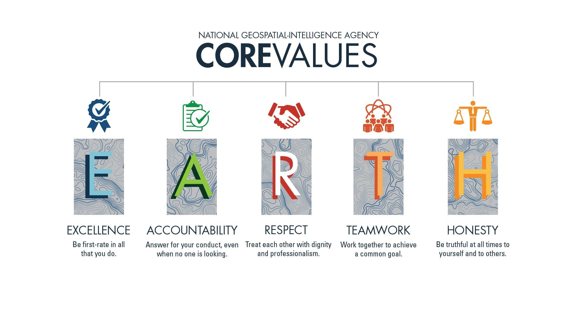
NGA Core Values

NGA's Heritage
In the 1990s, amid the upheaval of an emerging post-Cold War world order and space-based technological advances, a radical new concept took shape. The idea – to merge imagery and mapping elements from across the DOD and the IC – challenged by conventional wisdom and threatened decades-long ways of doing business. The impetus for such a radical idea came from lessons learned after Operations Desert Shield and Desert Storm, which highlighted imagery and mapping shortfalls.
To a handful of visionaries, the challenges exposed by the Gulf War provided an opportunity to reimagine imagery and mapping assets into a single entity – what eventually became the National Imagery and Mapping Agency (NIMA). Though initially resisted by many in the IC and DOD, NIMA garnered strong support from key individuals, such as Director of Central Intelligence John Deutch, who championed the concept. Thanks to their persistence, the NIMA concept became reality on October 1, 1996.
The success of the new agency would depend on the agility and determination of the thousands of men and women called on to redefine their work. With its formation, NIMA inherited the legacies of several imagery and mapping equities, including the complete absorption of the Defense Mapping Agency (DMA), the National Photographic Interpretation Center (NPIC), the Central Imagery Office, and the Defense Dissemination Program Office, as well as imagery elements from the Central Intelligence Agency, the Defense Intelligence Agency, the National Reconnaissance Office, and the Defense Airborne Reconnaissance Office.
Each of these predecessor organizations had a proud heritage of service to the nation, which had forged strong cultural identities among their respective workforces. Highlights of this service included the crucial role played by NPIC imagery analysts in the Cuban Missile Crisis (1962) and the significant contribution of DMA cartographers to negotiations in the Dayton Peace Accords (1995). In its early years, NIMA had to overcome a residual external resistance to the single-agency concept, as well as internal rivalries fostered by the competing inherited claims on workforce heritage and identity.
Despite these challenges, NIMA achieved several notable successes in its first years, including the Shuttle Radar Topography Mission. This groundbreaking collaboration with NASA and its research and development center, the Jet Propulsion Laboratory, allowed NIMA to produce seamless, near-global Digital Terrain Elevation Data that remains a cornerstone of modern geospatial mapping and measurement.
Beginning in response to the terror attacks of September 11, 2001, and continuing throughout their long aftermath, NIMA began cementing a greater unity of purpose among its various imagery and mapping elements. In the wake of such world-altering events, old agency rivalries were set aside as new synergies were recognized and exploited to meet the challenges of an emerging global landscape shaped by the War on Terrorism. Key innovations driven by this new battlespace included greater reliance on emerging technologies, such as Unmanned Aircraft Systems, which provided real-time airborne imagery, as well as the formal merger of imagery and mapping analysts in cells such as the Targeting Fusion Center.
In 2003, Congress recognized the transformative work happening across the agency by officially renaming NIMA the National Geospatial-Intelligence Agency. More than just a name change, NGA cemented a new intelligence discipline – GEOINT – and gave rise to such developments as the establishment of the NSG, all of which ratified the innovative discipline and doctrine fueling the work of the agency. During these years, NGA provided distinguished support to military campaigns, including Operations Enduring Freedom and Iraqi Freedom, and played a pivotal role in the 2011 raid on the Osama bin Laden compound in Abbottabad, Pakistan.
Alongside its vital warfighter support role, NGA has accumulated a storied legacy in support of a variety of domestic and international humanitarian and disaster relief efforts, working in conjunction with such organizations as FEMA. These partnerships have helped bring stability to hard-hit communities facing every kind of natural disaster, spanning the likes of hurricanes, earthquakes and tornadoes, as well as humanitarian crises, such as the Ebola epidemic of 2014. NGA’s GEOINT expertise has also been used to combat criminal activities across the globe, including work to hinder the production and distribution of narcotics and wildlife trafficking.
Since the inception of NGA, the global landscape – and the threats emerging from that landscape – have continued to evolve. GEOINT has been a critical pioneer and partner in the fight against both long-term problems and unforeseen vulnerabilities. From its position as both a combat support agency and intelligence agency, NGA remains at the forefront of meeting the challenges of the 21st century, so we can help show the way to a better tomorrow.
Know the World, Show the Way…from Seabed to Space.

What We Do
Geospatial Intelligence
NGA provides a wide range of GEOINT analyses, data and services for customers, spanning from analysts to policymakers to warfighters. NGA advances national security objectives through GEOINT support to military operations, planning, decision-making, diplomacy, intelligence analysis, strategic and tactical warning, search and discovery, and targeting.
NGA analysts use GEOINT to continuously monitor and assess threats and challenges to the national security environment including nuclear weapons-related developments, counterproliferation, counterterrorism, treaty verification, foreign military capability assessments, and economic issues. NGA’s integrated operation centers provide near-real time exploitation and analysis of GEOINT sources. Additionally, NGA creates visual products such as 3-D animations, time sliders, custom graphics and fly-throughs which uniquely convey intelligence findings.
Warfighter Support
NGA enables the Department of Defense to plan missions, gain battlefield superiority, precisely target the adversary and protect our military forces. The agency focuses on global hot spots and provides timely indications and warnings to our military service members and national decision makers by monitoring, analyzing and reporting imminent threats.
NGA is committed to providing GEOINT support down to the last tactical mile. In addition to dedicated subject matter experts within many of our customers’ organizations, NGA also conducts a voluntary deployment program, embedding GEOINT professionals to support DOD operations worldwide. NGA provides direct military support to the DOD by developing, maintaining, and providing the World Geodetic System 1982 (WGS-84) and geodetic data to U.S. weapons systems.
Navigation Support
NGA prepares, compiles, publishes, distributes and maintains worldwide maritime and aeronautical safety of navigation databases, product and services in support of DOD and partner warfighters, U.S. government agencies, foreign and commercial partners, international treaties, and other agreements. NGA’s safety of navigation products and data include digital nautical charts, sailing publications, notices to mariners, airfield foundation data, vertical obstructions, flight information publications and the Digital Aeronautical Flight Information File.
In addition, NGA leads the transformation of maritime and air navigation systems, standards, products and services, converting legacy products into digital content for dissemination through government-owned web-based and mobile applications. These apps put the power of safe navigation into the hands of the user. Additionally, the agency has developed an industry-leading electronic library of 48,000 instrument flight procedures and is developing digital Flight Management System data. The library satisfies U.S. and international mandates to transition to GPS-based air navigation, ensuring continued access to worldwide airspace and airports in support of national objectives.
Imagery & Analysis
NGA specializes in mapping and imagery analysis of foundation data including topographic, elevation and terrain, land cover, and geodetic information. Combined, these elements help describe the word in which we live, specifically what, where and when it is happening and what is likely to happen next. The agency leads the Department of Defense and intelligence community in the production, procurement, assessment and cataloging of geospatial data.
Additionally, the WGS-84 provides the single reference frame to geolocate all GEOINT data to support safety of navigation, targeting accuracy and intelligence activities. Through constant monitoring, WGS-84 precisely defines latitude and longitude and provides the magnetic model to aid navigation and an Earth Gravitational Model that helps define global mean sea level. Anyone who fights wars, locates targets, sails a U.S. ship, flies a U.S. aircraft, makes national policy decisions, responds to natural disasters or even navigates with a cell phone relies on NGA.


